A Beginner’s Guide to Cumberland Island
Cumberland island is a large barrier island in southern Georgia. It contains miles of wide, undeveloped beaches, thousands of acres of maritime forest and marshes, and a tremendous amount of American history. It’s been on my list for years, and I finally made time for a visit. Though I only spent a meager 28 hours on the island, I was able to cover a considerable amount of ground in that time.

One of many beautiful Live Oak trees.

Sunrise from Sea Camp Beach
My intent with this guide is to help you decide if it’s worth the trip for you, and if so, provide some useful first-timer advice. Whether you’re planning a day trip or several nights of camping, you’ll need make a reservation on the ferry. Unless you have your own boat and make prior arrangements, it the only way to the island. Only sixty campers are allowed per day on the island, so reservations may be difficult to acquire, especially for weekends. The maximum amount of day trip visitors is 300 per day. Call (912) 882-4335 to check availability and make reservations.
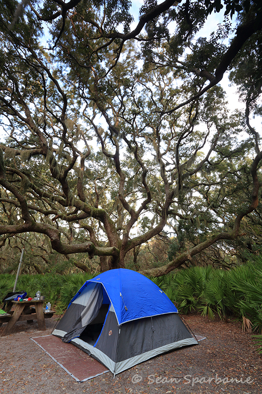
I opted to spend a few nights at Sea Camp. There are backcountry sites available, but there are numerous benefits to staying here instead. Firstly, you can bring a lot of gear. Whatever you can cram into a 4′ x 3′ wheelbarrow, you can haul to your campsite, which is about half a mile from the dock. Otherwise, you must carry it all on your back. The second most influential factor for me was the food storage containers that are only found at Sea Camp. Apparently, the raccoons and other critters are insufferable thieves, so storing food can be a real challenge. I’ll explain this in greater detail later on.
Bring whatever makes you comfortable for camping, and don’t forget sunblock and 100% Deet bug spray. The weather was cold and windy for me, so bugs weren’t a problem. However, I’ve heard they are positively horrid under normal conditions. No-see-ums, mosquitoes, ticks…nasty business!
Once you’ve done all the prep work, your adventure begins in St Marys, Georgia. Upon arrival at 113 St Marys St, you’ll notice the the ferries and a blue NPS building to the right. Head to the second floor of the NPS building and check in for your trip. You’ll be charged the camping fee at this point. Head back down and get all your gear ready to load on the boat. Once you get everything in order, you’ll have to drive past the intersection adjacent the NPS building and park in the grassy/sandy area on the right. Head back to the boat, and the deckhands will let you know when to load your gear. If you’re heading out alone as I did, you may have to hustle to keep up with everything.
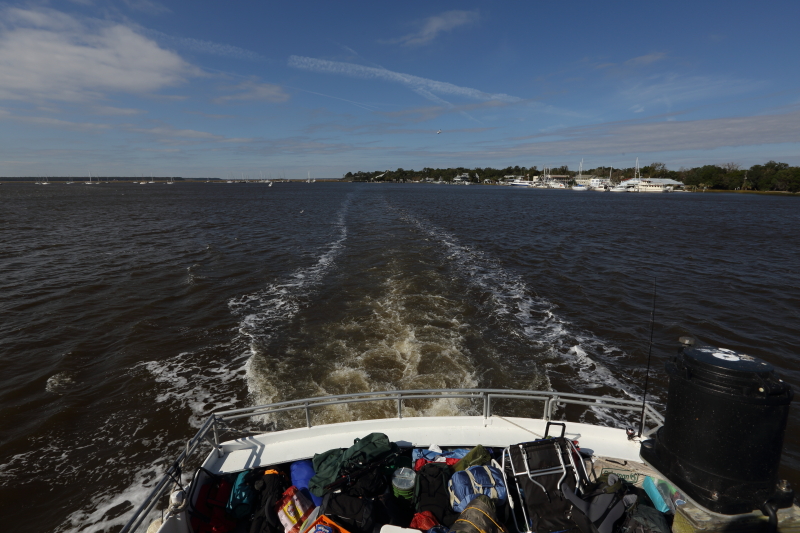
All your gear gets crammed in the stern area of the boat.
The boat ride takes about 40 minutes or so. We had strong headwinds, so it took a little longer. Once on the island, you can haul your gear off the boat and find yourself a wheelbarrow to help you get to your site. You’ll have to attend an orientation in the rangers office with all other campers. You’ll get your site assignment at this point. If it’s not full, you’ll be allowed to choose your own. Once you’re done here, grab your gear and head out to camp on the clearly marked east-west trail. Also of note: You can buy ice and firewood from the deckhands of the ferry. There are no other items available for purchase on the island.
Most of the sites are spacious, pretty, and relatively private. Each site contains plenty of space for tents, a fire ring with a grill, a picnic table, a tall pole to hang bags and trash, and a raised cage to store food. The raccoon and possums here WILL steal your food, garbage, or anything that smells interesting to them. Even the squirrels get in on the action if you let them. Be sure to use the cages for food, and don’t ever store food in your tent! There are restrooms, cold showers, drinking water, and a sink for washing dishes provided at Sea Camp. There are no trash collection services, so you must pack everything out.
The forest here is quite beautiful. I’m tempted to say it’s the highlight of the island. Old, twisted live oaks adorned with Spanish moss dominate the interior if the island. They tower over saw palmettos, the other dominant species. This is essentially how most of the wilderness looks. If you like this look, you’ll love the island.
Sea Camp

Anti-Critter food storage device. These are at all Sea Camp sites, and they work quite well.
On to explorations! Cumberland Island is home to a considerable amount of American history, and much of it is visible in the form of ruins. A short walk from Sea Camp to the south will bring you to the remains of Dungeness, a mansion originally built in the 1700s. It changed hands several times until it ended up property of Thomas Carnegie. The 59 room palace burned in 1959, and was never rebuilt. The park service now owns and maintains it.

A rear view of the Dungeness Mansion ruins

From the side stairway of Dungeness
This wiki article provides a much better description than I can put together http://en.wikipedia.org/wiki/Dungeness_(Cumberland_Island,_Georgia)
However, Actually being there, walking down the gated driveway towards the shell of this expired mansion, it was still able to impart a taste of it’s magnificence. It was no wonder the Carnegies ended up owning 90% of the island. I can only imagine how beautiful this site must have been in its prime.
All entrances are blocked, and the raised lawn surrounding the rear building are also off-limits, so you cannot get a close look at it. I suppose I understand the need for this (public safety concerns, vandalism, etc), but that didn’t change the fact that it was disappointing for me. I wanted to explore this place, touch the walls, and photograph it with an intimate perspective. It felt more like a museum piece than ruins. There may be tours offered, but those rarely offer the experience I’m after.
There are many secondary structures around Dungeness. Some you can get close to, some not. The area is well maintained, which I felt takes away from the ‘ruins’ experience. That being said, I suspect a lot of the grounds ‘maintenance’ is performed by one of the island’s permanent residents: The Horse.

One of the islands’ more handsome horses
There are many horses to be seen roaming the island, and a large amount can be found here at Dungeness. They aren’t handled by the park service, they are wild animals, so use caution around them. They’re used to humans ogling them, but they’ll defend themselves if they feel threatened or irritated. There’s plenty of other wildlife to see on the island. I saw a group of five wild boars running through the forest, a large buzzard eating an expired armadillo, and some white-tailed deer running in the dunes. You will also find gators near the ponds, and a variety of snakes, some of which are poisonous, so always keep your eyes peeled.
Heading further south, you’ll find a boardwalk that runs a good distance over the salt marshes. This is a nice, peaceful place to take in the sunset. I saw a few raccoons scurrying across the mud to grab their crustacean dinners. You can stick around and watch the reeds sway in the breeze until dark if you want. It’s very easy to find your way back after the sun sets since the trail is white gravel and wide enough for a truck.

Sunset at the boardwalk
You can also access the beach here, as you’re a short walk through the dunes to the surf.
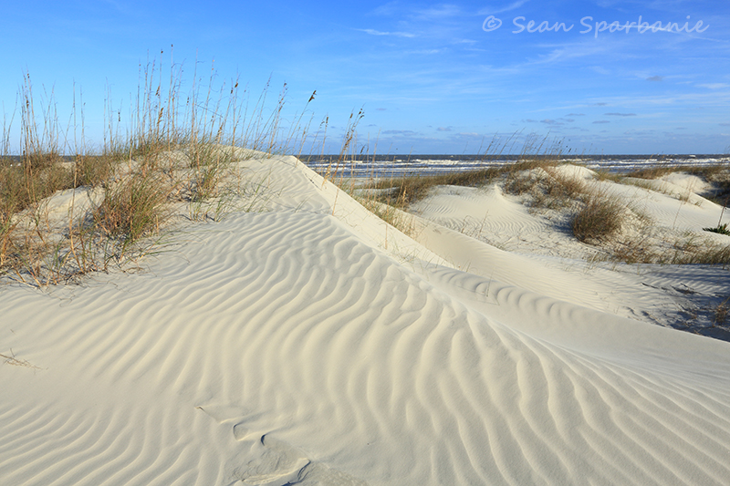
Aforementioned Dunes
The beach. Now, if you’re looking for a beach with an absolutely vast amount of space and solitude, then my friends, look no further. There are more than a dozen miles of coastline here, and no more than 300 visitors are permitted on the island during the day. only 60 campers overnight! If you hike a bit beyond the trailheads, you will have all the solitude you could want.

Vast and featureless
Unfortunately for me, the wind was positively awful with 40mph gusts coming off the Atlantic, so I wasn’t able to spend a lot of time here. The coast on this island has a very desolate, lonely feel to me. It seems to go on forever, and there’s no forest behind it, so it just felt barren. I didn’t see anything especially appealing from a photographer’s perspective, either. The coast is very flat with no noticeable features in the surf to stand out. I suppose of brilliant sunrise would look nice in the ripples and reflections, but I wasn’t afforded any good light to work with for this trip.
I was hopeful for a good astral display, but again I was a bit disappointed. There’s some variety of power plant to the south, and the light pollution it creates is very significant.

The awful source of light pollution
To the west, St. Mary’s creates a bit of glow in the sky, and to the north, Jekyll Island generates a faint light as well. Due east offered a decent view, however. Not the greatest I’ve seen, but good enough for a shot or two. It’s probably a little better from Stafford beach or even further North, however.

A due east view over the the Atlantic. I had to adjust white balance on the shot to remove the orange hue from the light pollution
On my second day, I rented a bike for the day for $16. You can get these from the ferry deckhands, along with firewood and ice. For an extra $4, you can keep the bike overnight. It’s a basic single-speed road bike with coaster brakes, and it does the trick for the most part. Since I wanted to cover as much ground as possible in a short time, it was the best option. My goal was to head to the far north end of the island to see the wharf ruins, and the old baptist church. The main road up the island, like every road on the island, is unpaved. While you’re under the canopy of forest, the going is pretty easy. There are many graded or ‘washboard’ sections of the road to provide traction for vehicles. These are remarkably uncomfortable on a bike, so you have to pay attention to avoid them. The clearings are somewhat difficult to pedal through because of the loose sand, so you may have to walk your bike on occasion. There are still private residences on the island, so watch out for cars. I encountered only two the whole day, and they were both NPS vehicles.
I spoke with a ranger piloting one of those vehicles, and he advised me to skip the wharf ruins, and head to Plum Orchard instead. This was merciful news, since the latter option was only 2 more miles instead of 8.
I took his advice, and hung a left towards this Georgian Revival mansion.

Yep, it’s definitely a mansion.
This mansion, unlike Dungeness, is in great shape. The park service has volunteers on staff to give guided tours of the 24,000 square foot home, and I arrived just in time for one. My tour guide was friendly and knowledgeable, and I found the tour to be interesting. The home was built by Lucy Carnegie for her son Gorge and his wife Margaret. The home was a technical marvel for its time. It had electricity more than 20 years before the mainland town of St. Mary’s. An elevator, indoor pool, squash tennis court, and many other interesting features are outlined in the tour.

Downstairs looking towards the parlor.

Medicine shelves in the mansion

View of the long upstairs hallway

The kitchen
After leaving the mansion, I headed back down south to check out Stafford beach. Turns out it looks very similar to the other beaches I’d already seen. Flat, nearly featureless, and vast. That being said, being on the beach is better than not being on the beach. The wind had been tamed to a somewhat manageable 20mph, so I stuck around a little to enjoy the surf a bit. After getting my fill of sand in my camera gear, I headed back to camp via the Parallel Trail.

One of many peaceful views of the Live Oaks
Even with the winds still whipping on the beach, the forest remained calm. I enjoyed this trail much more than the main road. I don’t think I was supposed to have the bike here, but I don’t think anyone was too worried about it. Zooming through the narrow forested trail on the bike was most definitely worth the risk of getting yelled at by a ranger.
Once I got back to camp, I decided to make a last minute rush to abandon the island. The forecast was calling for an inch of rain the next day, and I didn’t want to be around for it. I broke camp, hauled gear to the ferry, and make it with 5 minutes to spare. Sure enough, the next day was a cold, water-logged mess.
As a photographer, I can’t say I recommend spending too much effort shooting here. I make this judgement based on the lack of an exceptional beach. Keep in mind, the weather while I was on the island was terrible. Windy, rainy, cold, etc. That doesn’t generally make for a happy photographer, especially the windy part. Perhaps if I had better conditions and more time to explore, I’d be writing something different. That being said, I found Hunting Island in SC to be a much more interesting beach to photograph. It’s much easier to access, as well. It does not have a live oak forest, though, and that makes a big difference. For me, the historical significance of the island seemed to be a more interesting draw. Maybe I’ll give it another try in better weather, but I can’t say I’m terribly motivated to do so.